
Practicing inclusive history requires accumulation of deep knowledge of the landscapes we inhabit and the environments that we influence over time. This knowledge derives from a close examination of features that our senses discern in the places where we live—the landscape—as well as the spaces that we inhabit and that our choices affect—the environment. Places that some may perceive as “natural,” such as Petroglyph National Monument in New Mexico, have physical attributes that confirm human influences over millennia. Inclusive environmental history takes into account the landscapes, the places that we can see and touch, and the effects that we have on these landscapes. This influence may be invisible to our senses. Racism, sexism, political partisanship, economic systems, class, and other forces have shaped—and continue to shape—environments in which we exist. The effects of these forces accrue most devastatingly to frontline (and fence-line) communities, i.e., those who live closest to sources of pollution that result from human decisions. Human-caused (anthropogenic) effects are most evident in the past century with the foremost outcome being climate change.
When did humans begin to leave significant marks on the landscape, and when did their actions accumulate to influence the environment? An increased understanding of both of these—landscapes and environments— can inform our actions as we work toward a more just and equitable future. Environmental history addresses both, as analyses often apply an environmental justice lens to investigations of historical and contemporary land and resource use and consequences of that use. Learning more about the physical location (landscape) and how humans act as agents of change (the anthropogenic environment) over time requires assessment of a combination of tangible and intangible natural and cultural evidence.
The iterative process starts with a geographic focus, i.e., the landscape, associated with a museum or historic site. Historical interpretation at the site might center on 1880s rural life, but an inclusive environmental history needs to start long before 1880, and continue to the present, thus acknowledging the factors affecting the site before and after its perceived period of significance. Sources might include collections of natural objects housed at museums and specialized archives (e. g., minerals and gems, fossils, biological specimens), written records, visual or creative works (e. g., photographs, paintings, books), belongings resulting from extractive industry (e.g., a cast-iron stove or a sewing machine in a mahogany case), and intangible cultural heritage (storytelling, ritual, music, oral history, and other evidence of cultural practice). From this accumulation one can document change in landscapes and communities and include the museum or historic site as an agent of change.
Linking a site focused on the 1880s to current concerns requires high-level thinking, a synthesis of data about the soil, agricultural practices, water availability, power sources and energy use over time, processing industries, transportation networks, waste management, and numerous other examples of human manipulation as precursors to the Great Acceleration—the causes and consequences of the human footprint on the environment—within our era of the Anthropocene. All place-based history informs us about environmental change, be that past or present.
Consider the history of the site under consideration for an environmental history evaluation, the reasons for studying and protecting it, the controversies that swirled around it, and the power and influence wielded by those who preserved it. This viewpoint can illuminate crucial history within a site’s institutional history and help us link events from the past, collected and preserved, to today’s highly charged and politically divisive topics. Addressing embedded narratives is the historian’s duty—to facilitate inquiry and convene conversations that inform future decisions. Practicing inclusive environmental history can tease out evidence of injustice in a place over time, but it can also prompt more self-aware decision-making into the future.
A Sense of Place
Look out of your window—it frames, literally, a landscape, and figuratively, the environment. Do you have a view of a city center, farm, seashore, neighborhood park, or warehouses? How do you frame (or interpret) this view in terms of public history? Consider the window a lens through which we see the present clearly; but what about the past? What do we have to do to discern who and what was included and excluded then? Are there members of the community within this view who can speak to the causes and consequences of environmental and social injustice? Does a diversity of voices exist to convey experiences across lifetimes and across cultures? How has the physical environment changed over time and has this been documented in photographs, diaries, oral histories, and newspapers? Who has told the history of the place to date, and how does a more inclusive environmental history expand our understanding?
The Long Durée: Changing Landscapes
To have a sense of the environment today, it is important to know how the physical landscape changed through time. Geographical and geological features serve to inform why humans would settle in or avoid certain landscapes. What was the landscape like in spans of time: one million years ago, ten thousand years ago, one thousand years ago, five hundred, one hundred, fifty, ten, and today? What do we want it to be in the future? How we humans have changed landscapes also tells a story. When did humans arrive—that is, who first populated and then altered the local environment? How did they conduct their lives? Were they nomadic? Did they hunt or practice agriculture? What were their societies and cultures like? What precipitated change? These large timeframes can be used to learn about the physical environment and how it affected and influenced social changes over the centuries.
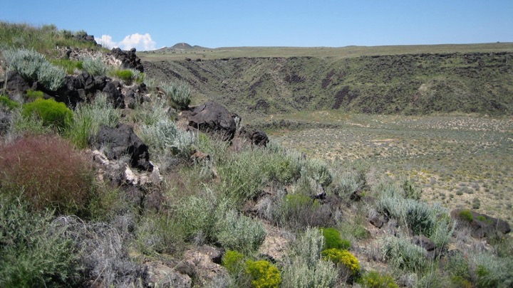
For example, Petroglyph National Monument in the Albuquerque suburbs reveals a landscape rich in geological and human history, being close by the Rio Grande River. Volcanoes, visible in the background, erupted as recently as 140,000 years ago. As noted by the National Park Service, some of the 25,000 petroglyphs in this area date to 2000 BCE, reflecting pre-Pueblo cultures. Most of the rock-drawings date from 1300 to 1650 CE, with illustrations depicting people, snakes, mammals, and birds. The Pueblo people settled in this region around 500 CE. Carvings made by the Spanish in the 1500s and 1600s, then other settlers, and graffiti deliberately defacing older petroglyphs represent phases of contact, colonization, annihilation, but also persistence. The casual observer might see the petroglyphs, but it requires attention to discern the evidence of centuries of contested occupation and engagement to develop cultural sensitivity to the magnitude of environmental injustice evident in what some may perceive as a natural landscape.
Landscape as Artifact
The landscape of a historic site can be its largest artifact, though few catalog it as such. The scrutiny of cataloging, requiring measurements and descriptions and statements of significance, can prove invaluable when focusing on the essentials of inclusive environmental history. The two examples that follow affirm how close analysis of elements of landscapes—water or trees—can open our eyes to the multiple meanings of landscapes more generally.
Water: Flowing from physical to social, from inequity to justice
Water is everywhere and because of its familiarity, some may overlook the power of water as an entry point for inclusive interpretation. Water shapes landscapes. It supports travel and trade. It draws livestock and wildlife to drink and people to fish, forage, and swim. It also separates those who have control over it from those who do not. When is water a commodity that people own? Who controls its use and sets its price? Who has clean, safe water to drink, and who does not? Water becomes an entry point into discussions of sewage, pollution in our rivers and oceans, and industrial agriculture with lagoons of animal waste spilling into creeks, rivers, and beaches. Severe storms, hurricanes, and floods destroy homes, neighborhoods, and public transportation. Drought and floods in agricultural areas greatly reduce crop production and increase food costs. Fracking, a process that diverts water to extract oil and natural gas, depletes aquifers. Dams and reservoirs address human-water needs but also destroy indigenous fisheries as well as natural waterways. Water is at once a physical feature of the landscape, stagnant or flowing, and evidence of environmental manipulation through human exploration and exploitation.
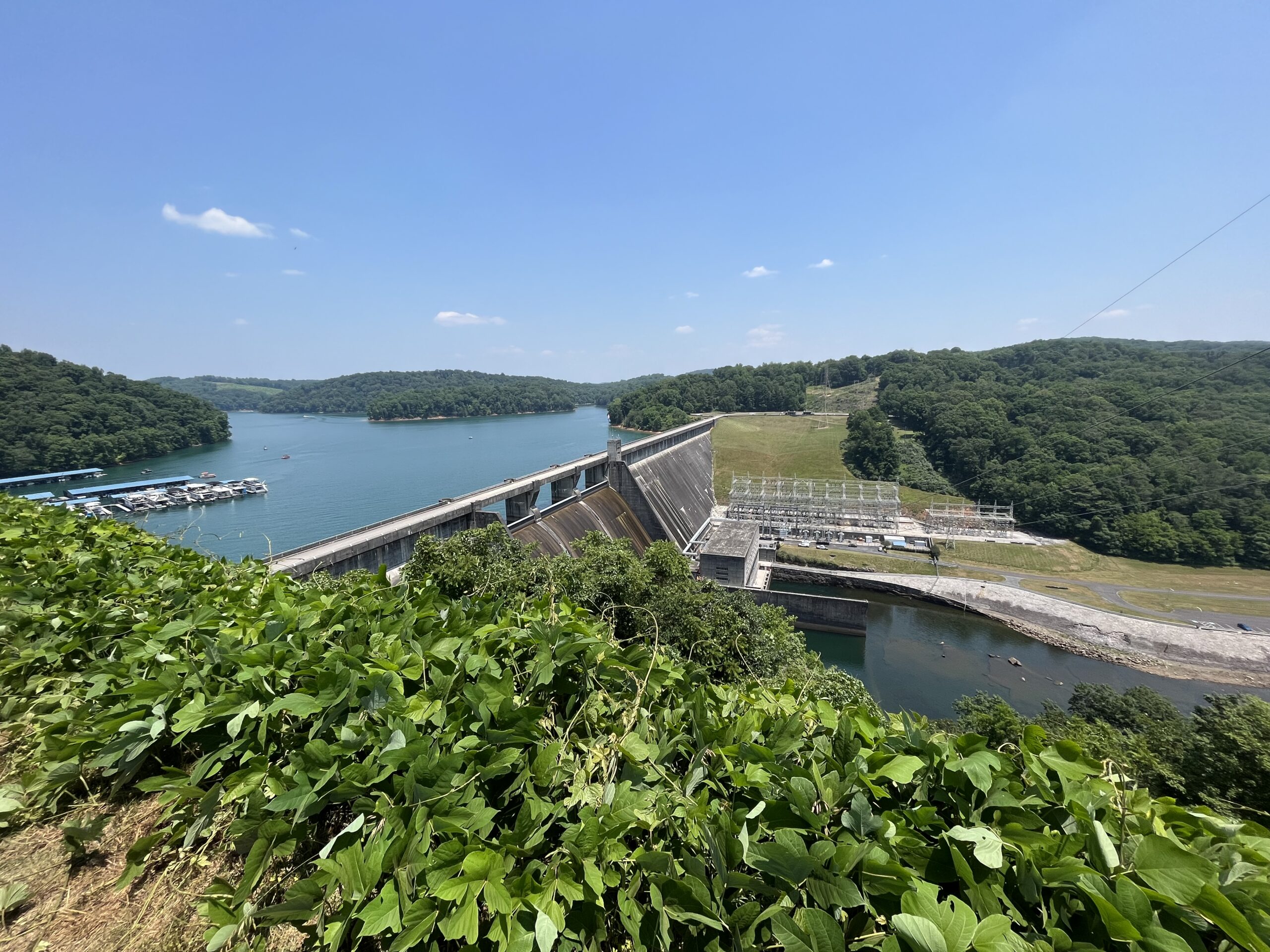
The view of Norris Dam (Rocky Top, Tennessee) belies the complexity of water. The Tennessee Valley Authority built the Norris Dam in the mid-1930s to reduce flooding and generate electricity. What did locals think about flooding or rural electrification before the dam project began? Who did the dam project displace, and was this temporary or permanent? Were residents of different races and ethnicities all affected in the same way by the project? Who built the dam, both as investors and laborers? Who profited from it? Today, the reservoir, marina, and park attract tourists and recreational boaters. On land, visitors can get a close look at kudzu, the leafy plant in the foreground, touted during the 1930s for its potential to reduce soil erosion, and now identified as an invasive species. Controlling water propelled this public works project, one with multi-faceted consequences. Today, aging dams are being dismantled to restore waterways, fisheries, and outdoor recreation. With this, there is increased interest in learning about historical uses of such waterways and Indigenous rights and beliefs about water systems. All of this reflects that clean water is fundamental to all life systems.
Trees: A Measure of Inequity in Urban Environments
More than 70,000 tree species exist. You can see the trees outside your museum or historic site window, but can you name them? Can you identify a tree like the one that yielded the wood in your house frame, floor, table, or chair? How do you document trees in one place historically in addition to using familiar tools such as maps and plat books, photographs, and weather records? The trees themselves are sources of information. You can measure tree girth to approximate its age. Trees recently cut down provide an “archive of nature,” in the words of Sam White, as tree rings provide a timeline into which you can insert key environmental and anthropocentric events.
Urban trees historically denoted prosperity as Catherine McNeur has shown in Taming Manhattan, a study of neighborhoods and land use in antebellum New York City. Shade trees such as oak, maple, and elm trees can survive for one hundred or more years if they do not succumb to environmental factors (drought, heat, cold, storms, disease, insects). When did tree-lined urban streets give way to treeless expanses of concrete? Answers lead naturally to a discussion of forces associated with global warming and the Anthropocene. Trees and green spaces sequester carbon, but human activities, including land-use practices, leading to increased accumulation of carbon dioxide (CO2) and other greenhouse gas emissions, have outpaced Earth’s carbon-capture capacity.
Local effects are evident in treeless urban environments where a lack of shade results in increased solar heat. The result is buildings, sidewalks, and parking lots that are heat-sinks by day, which then radiate that heat into the night. Daytime temperatures in urban neighborhoods (called heat islands) can be up to 7° F warmer than in tree-shaded neighborhoods. Humans do not thrive under conditions of continuous high temperatures. Thus, living in a heat island becomes an environmental justice issue. The resulting heat island inequity has known negative effects on human health, from loss of sleep to heat-related illness or death. Poverty exacerbates the negatives because impoverished people end up paying more for their utility bills because the built environment retains heat through the night. The organization American Forests has assigned a Tree Equity Score to more than 200,000 neighborhoods in the United States. This score shows the overlap between fewer trees and communities experiencing the stress of living in their neighborhoods. Thus, heat island inequity and tree equity can be used to develop compelling narratives of environmental justice in urban settings.
These examples indicate how elements of landscapes—water and trees—can add new dimensions to our understanding of the environment. Both indicate how assessing real experiences of life with or without water or with or without trees can result in more complete environmental history that forms the basis for inclusive interpretation of the environment.
Environmental History in Images
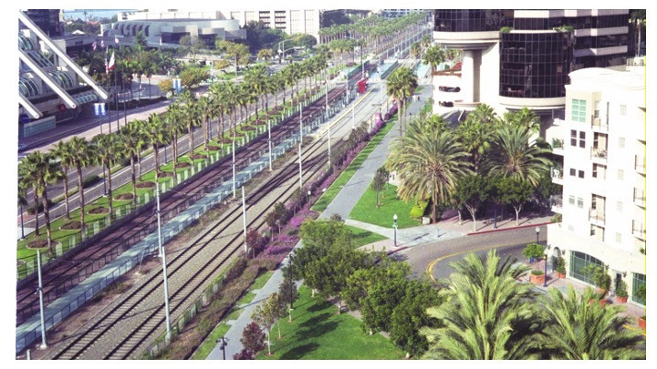
You can start a more inclusive interpretation of the environment by looking at the familiar with a new lens. The photograph of downtown San Diego features a public transportation system (light rail) near a convention center and bordered by landscaped walkways. This building-scape contains no evidence of the historic landscape obliterated by urbanization and highways. Nor does it show the people of San Diego: the homeless, migrant workers, undocumented immigrants, navy personnel, and office workers. Without San Diego residents in city views, the issues they face relative to that urban environment remain invisible. One example, the ongoing crisis of hepatitis A virus infection among unhoused people, indicates a lack of access to public toilets and clean water and other resources essential for human health. It’s tempting to simplify peopleless urban landscapes and urban environments teeming with humanity as a simple dichotomy but instead we must investigate the complex human-landscape-environment relationships at the core of both to arrive at inclusive interpretations of the environment.
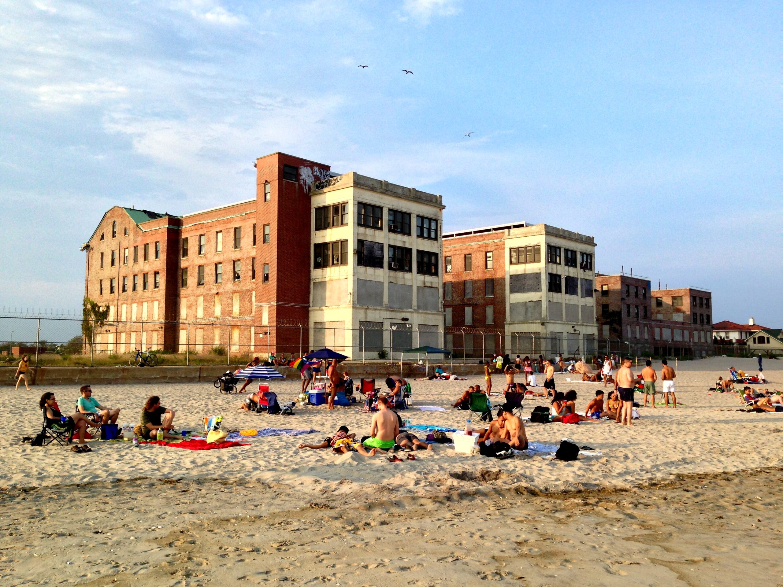
This human-landscape-environment relationship appears more prominently in the view of Jacob Riis Beach in New York City. The ruins of a tuberculosis hospital from 1915 loom in the background, acting as a shield protecting LGBTQ+ beachgoers from unwanted intrusions, as described by Iezzi and Ronan (2022). Such beach photographs can lay the groundwork for New York histories focused on neighborhoods, ethnic enclaves, public versus private spaces, public health and tuberculosis sanitariums, segregated recreation areas, and alternative land-use by farming and fishing families to name a few.
Conclusion
You can start inclusive environmental history now. Look closely at the landscape in your neighborhood or at your museum or historic site. Itemize the features you see. Turn to tangible and intangible culture and archives that document the human, biological, and geological evidence of what came before, and explore current work that contributes to the long history of the environment of your site. With this context established, you can start to connect the historic to the present and provoke conversations that can lead beyond understanding to cultural change.
Suggested Readings
Iezzi, Annie and Katie Honan. “Demolition of Long-Abandoned Medical Center Could Leave Queer Beachgoers Exposed.” The City, May 8, 2022. https://www.thecity.nyc/2022/05/08/demolition-abandoned-medical-queer-beach/
Keogh, Luke, Liisi Jääts, Nina Möllers, and Libby Robin. “Environmental History in Museums: Past Practice and Future Opportunities.” In The Routledge Handbook of Environmental History, edited by Emily O’Gorman, William San Martin, Mark Carey and Sandra Swart. 385-398. New York: Routledge, 2024.
McNeur, Catherine. Taming Manhattan: Environmental Battles in the Antebellum City. Cambridge, MA: Harvard University Press, 2014, Chapter 2.
McNeill, J.R. and Peter Engelke. The Great Acceleration: An Environmental History of the Anthropocene. Cambridge, MA: Harvard University Press, 2016.
Reid, Debra A., and David D. Vail. Interpreting the Environment at Museums and Historic Sites. Lanham, MD: Rowman & Littlefield, 2019.
Reid, Debra A., Karen-Beth G. Scholthof, and David D. Vail, eds. Interpreting Science at Museums and Historic Sites. Lanham, MD: Rowman & Littlefield, 2023.
Reid, Debra A., and David D. Vail. Technical Leaflet 289, “Interpreting the Environment at Museums and Historic Sites.” History News, 75, Winter 2020. https://learn.aaslh.org/products/technical-leaflet-289-interpreting-the-environment-at-museums-and-historic-sites
Fitzgerald Michelle, Julia Rose, and Ian Waggoner. “Naturally Beautiful: Finding Environmental Advocacy in a Historic House Museum.” History News 75, no. 4 (Autumn 2020). Pp.13-19.
White, Sam. “Communicating Climate Change with Archives of Nature and Archives of Societies.” In Interpreting Science at Museums and Historic Sites, edited by Debra A. Reid, Karen-Beth G. Scholthof, and David D. Vail, 3-8. Lanham, MD: Rowman & Littlefield, 2023. https://rowman.com/ISBN/9781538172742/Interpreting-Science-at-Museums-and-Historic-Sites
Online Resources
San Diego
Barona Cultural Center and Museum https://www.baronamuseum.com
California Museum https://californiamuseum.org
Old Town San Diego State Historic Park https://www.parks.ca.gov/?page_id=663
San Diego History Center https://sandiegohistory.org/archives/biographysubject/timeline/
New Mexico
Indian Pueblo Cultural Center https://indianpueblo.org
National Hispanic Cultural Center https://www.nhccnm.org
Museum Hill https://www.museumhill.net
Petroglyph National Monument https://www.nps.gov/petr/index.htm
Tennessee
Manhattan Project, Oakridge https://www.nps.gov/mapr/oak-ridge.htm
Norris Dam State Park https://tnstateparks.com/parks/norris-dam
Tennessee Valley Authority https://www.tva.com/About-TVA/Our-History
New York City
Gateway National Recreation Area http://www.npshistory.com/publications/gate/index.htm
Jacob Riis Park https://www.nps.gov/gate/learn/historyculture/jacob-riis-park.htm
NYC LGBT Historic Sites Project https://www.nyclgbtsites.org/site/beach-at-jacob-riis-park/
Trees and Heat Islands
American Forests Tree Equity Score https://www.americanforests.org/tools-research-reports-and-guides/tree-equity-score/
Urban heat islands https://www.epa.gov/heatislands/learn-about-heat-islands
Water
US Environmental Protection Agency https://www.epa.gov/ground-water-and-drinking-water
Water Alliance https://uswateralliance.org
AUTHORS
~ Karen-Beth G. Scholthof is professor emerita at Texas A&M University, Department of Plant Pathology and Microbiology. As a plant virologist, she researched the molecular biology of host-virus interactions. Her historical research focus is the history of tobacco mosaic virus and the social and scientific influences of plant pathogens on our environment. She is a fellow of the American Academy of Microbiology, the American Association for the Advancement of Science, and the American Phytopathological Society.
~ Debra A. Reid is Curator of Agriculture and the Environment at The Henry Ford and professor emerita at Eastern Illinois University, Department of History. She studied cultural geography at the undergraduate and PhD levels. Her historical research focuses on rural and minority cultures and Black farm owners among other topics. She is a fellow of the Agricultural History Society and recipient of distinguished service awards from the Association for Living History, Farm and Agricultural Museums and from the Agricultural History Society.